Worcester under water
Will this work?
November 19th, 2005
To help prevent flooding in Hylton Road, This earthworks “bund” has just been built using clay dug from new marina at Upton Upon Severn. The clay was delivered in barges.
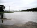
Carrington Bridge July 2007
November 19th, 2005
The view from Carrington Bridge.
Click on pictures to view full size
South of the city,looking upstream towards Worcester, this was the only Severn crossing at Worcester during the floods in July 2007.
North Quay July 2007
Worcester Bridge blocked.
Flooded Cricket Ground.
The cricket ground has been flooded many times before, but July 2007 floods put paid to cricket for the rest of season.
The old road bridge crossing the Teme, can just been seen under the raging torrent. July 2007
The chimney is at the old power station site, now residential accommodation
Powick roundabout on the southern link an extremely busy place (usually.) July 2007
This is the main road to Malvern. Alternative routes through Kempsey and Bransford were also flooded. The water was almost blocking all lanes of the Southern Link roundabout.
Floods at Pitchcroft 2005.
Railway bridge near Pitchcroft.
Floods at North Quay 2007
Worcester Floods 1947The Old Rectifying House was flooded for many weeks and here is a customer climbing up for a pint from Mr J. Clarke’s the licensee’s family. What would Health and Safety have to say about this?The Old Rectifying House July 2007Thanks to Derick for this picture, looks like everybody has gone home.
Flooded North Quay.
A flooded North Quay Road before Worcester Bridge was widened in 1932.
Diglis Lock under water.
Flood Levels at Worcester.
Tablets set into wall near watergate leading to College green, denoting Severn flood levels, the deepest and most damaging was in November 1795.


Flood Barrier.
November 19th, 2005
Flood Barrier Nov 2005.
This barrier has been erected to prevent Hylton Road flooding. Consisting of aluminium frames with waterproof membrane attached. This appears to work quite well, but the cost of barrier is £600 per 4 feet width.
This flood defence has just been put up again on Friday the 8th of December 2006
Recent flooding at Worcester promoted me to ask Max: Instead of bringing out these flood barriers every time. Why not permanently build the banks of the Severn up to barrier height? He gave me this reply.
To be safe the riverbank would have to be raised about 10-12 ft, which would be unsightly for the rest of the year. One mans flood defence is another mans flood. All these barriers are pushing the water up elsewhere. Worcester flood residents should be worried about the new road at Upton, which has been, raised 1/1/2 metres at the bridge. Although it has arches, as your Worcester Bridge picture shows, they quickly jam with rubbish. After initial denials the Environment Agency are now admitting the Southern Link Road holds up a flood. The soil dumping at Hallow tip will push a high flood across towards Park Avenue. In 1947 the flood rose up Park Avenue to Sabrina Avenue and then flowed through a sandpit, which has now been filled, and had houses built on it. The tide made this flood rise about 6 inches; we are not so far off sea level. In the 1770’s there was a stream running from the Severn called Chacewater. It crossed the present Park Avenue into Lavender Road and drove a large waterwheel, which drove the pumps to raise the water up the Tower to supply the city. Recent clearance of the waterworks revealed the remains of the pump house. This is where a high flood could run. Max
The River Severn has been neglected by the City which owes its origins to the Ancient Britons fording point which survived until the 1960’s alongside North Quay.It is good to see the Rowing and Canoe clubs thriving and now joined by the spectacular Dragon Boats, all following in the wake of the trading vessels which created this countries wealth. Unfortunately no control has been exercised on the growth of trees and bushes all along the towpaths and adjoining fields which used to be kept clear and we can expect floods to be higher than in past years. In 1886 the river rose to the top of the central arch of Worcester Bridge ,a rise of twenty five feet over the Diglis Weir crest which maintains the lowest level of the river. From Worcester to Gloucester the river is eight feet deep and six feet to Stourport. Dredging has no effect on the rivers capacity to carry floodwater. Worcester bridge stands on a rock bed which can not be deepened, known as a Ketch of which there are many in the Severn. Max.

New Road Worcester.
The floods in New Road cuts off the city.

Fire engine returns through the flooded New Road.

No play today at New Road. July2007


