Carrington Bridge July 2007
basil | 11/19/2005 | 2:25 pm
The view from Carrington Bridge.
Click on pictures to view full size
South of the city,looking upstream towards Worcester, this was the only Severn crossing at Worcester during the floods in July 2007.
North Quay July 2007
Worcester Bridge blocked.
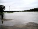
Flooded Cricket Ground.
The cricket ground has been flooded many times before, but July 2007 floods put paid to cricket for the rest of season.
The old road bridge crossing the Teme, can just been seen under the raging torrent. July 2007
The chimney is at the old power station site, now residential accommodation
Powick roundabout on the southern link an extremely busy place (usually.) July 2007
This is the main road to Malvern. Alternative routes through Kempsey and Bransford were also flooded. The water was almost blocking all lanes of the Southern Link roundabout.
Floods at Pitchcroft 2005.
Railway bridge near Pitchcroft.
Floods at North Quay 2007
Worcester Floods 1947The Old Rectifying House was flooded for many weeks and here is a customer climbing up for a pint from Mr J. Clarke’s the licensee’s family. What would Health and Safety have to say about this?The Old Rectifying House July 2007Thanks to Derick for this picture, looks like everybody has gone home.
Flooded North Quay.
A flooded North Quay Road before Worcester Bridge was widened in 1932.
Diglis Lock under water.
Flood Levels at Worcester.
Tablets set into wall near watergate leading to College green, denoting Severn flood levels, the deepest and most damaging was in November 1795.


